


Remembering a forgotten village
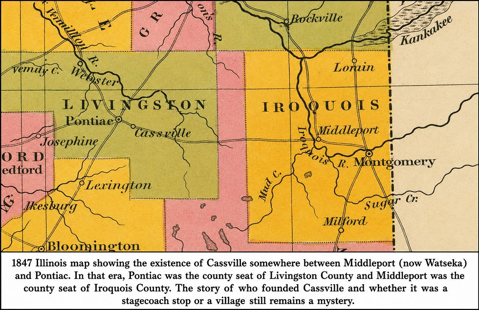
Several ghost towns once existed in the Fairbury area.
The histories of Avoca, Champlin, Lodemia, Potosi Corner, and Rosealthe are fairly well understood. Cassville, however, remains a mystery.
The first mention of the existence of a Cassville, Illinois, is the April 29, 1915, obituary of Civil War veteran George Washington Sutton. This obituary states that he spent his childhood in Cassville, Illinois, from 1846 to 1861.
Further genealogical research indicates that whoever wrote the obit mistakenly said Cassville, Illinois, when it should have said Cassville, Wisconsin. Records indicate that Mr. Sutton spent the rest of his life after the Civil War in Wisconsin.
The next mention of the existence of Cassville, Illinois is an 1847 map of Illinois. This map is titled “A New Map of Illinois with its Proposed Canals, Roads & Distances from place to place along the Stage & Steam Boat Routes” by S. Augustus Mitchell from Philadelphia.
This 1847 map shows an east-west route from Middleport to Pontiac. In 1847, Pontiac was the county seat of Livingston County and Middleport (now Watseka) was the county seat of Iroquois County. Because this route connected two county seats, it is likely the travelers on this route included attorneys, judges, land buyers, mail carriers, merchants, and settlers.
The stop in Cassville is shown on this route near the present-day village of McDowell. It is not clear from this map whether this route was a stagecoach route or just a road.
Many Illinois towns and counties were named after popular politicians. For example, Livingston County was named after Edward Livingston, a prominent statesman who served as U.S. Secretary of State under President Andrew Jackson.
Today, there are towns named Cassville in Georgia, Indiana, Missouri, New York, Pennsylvania, West Virginia, and Wisconsin. Some of these towns were likely named after Lewis Cass, a prominent Michigan territorial governor, U.S. senator, and presidential candidate. It is possible Cassville was also named after Lewis Cass.
The 1878 Livingston County history book recounts that Lewis Cass ran for president in 1848 and he received 130 votes in Livingston County. The 1848 U.S. presidential election was won by Zachary Taylor, the Whig Party candidate and hero of the Mexican-American War. He defeated Lewis Cass, the Democratic candidate, and former President Martin Van Buren, who ran on the new Free Soil Party ticket.
In 1849, Mr. Mitchell published a map of the eastern half of the United States. It was titled, “Mitchell’s new Traveller’s Guide through the United States Showing the Railroads, Canals, Stage Roads & with Distances from Place to Place.”
This map shows a different route from Middleport to Pontiac. On this 1849 map, the route starts at Middleport and heads west to Oliver's Grove (about three miles south of present-day Chatsworth). The road then heads northwest from Oliver's Grove to Cassville and on to Pontiac. Since the title of this map includes railroads, canals, and stage roads, this was likely a stagecoach route, and Cassville was a stop on that route.
Five years after Mitchell published his travel guide, Ensign, Bridgman & Fanning published another map titled “Railroad and County Map of Illinois showing its Internal Improvements in 1854.” This map shows the same route from Middleport, Oliver’s Grove, Cassville, and Pontiac.
On this 1854 map, Cassville is shown on the Vermilion River just southeast of Pontiac. This is also the approximate location of present-day McDowell. As with many early maps of Illinois, this 1854 map has at least two mistakes. It shows Avoca and Indian Grove southwest of Pontiac instead of the correct direction of southeast of Pontiac.
In 1854, the Chicago & Alton railroad came to Livingston County. It ran southwest from Pontiac down to Bloomington. This railroad is shown on the 1854 map.
In 1857, the Peoria & Oquawka railroad laid its tracks from Peoria east to the Indiana border. Fairbury was one of the new towns founded along this new railroad track.
After being shown on the 1854 railroad map, Cassville disappears from the radar screen. No map after 1854 shows the existence of Cassville.
Pontiac became the county seat when Livingston County was formed in 1837. Middleport became the Iroquois county seat in 1839. Because many people needed to travel between the two county seats, there was likely a need for a road or stagecoach connecting the two towns.
Livingston County transportation changed dramatically when the Chicago & Alton line ran through Pontiac in 1854, and the Peoria & Oquawka (TP&W) ran through Fairbury in 1857. These two railroad lines eliminated the need to travel by horse or stagecoach from Middleport to Pontiac. This change in transportation likely explains why Cassville is not shown on any maps after 1854. The Middleport to Pontiac road or stagecoach route was only needed from about 1839 until 1857, or about 18 years.
The search to solve the mystery of Cassville will continue. The information needed to solve this mystery likely exists but has not been digitized so researchers can find the key documents.
Dale Maley's weekly history article is sponsored by Dr. Charlene Aaron.


Comments